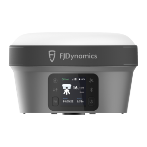
FJD TRION™ V10i GNSS System with Visual Positioning

$4,490.00

Visual RTK rover with AR stakeout + Visual Measure using dual cameras and an OLED screen for faster, safer field work.
Built tough with IMU tilt (0–60°), 1408-channel GNSS, IP68, and a 7000mAh battery (≈15h rover) + 30W PD fast charge.

FJD TRION™ V10i GNSS System with Visual Positioning
This item: FJD TRION™ V10i GNSS System with Visual Positioning
$4,490.00
$4,490.00
FJDynamics D10 Tablet
$2,490.00
FJDynamics E600 Controller
$1,890.00
FJDynamics UA80 Tablet
$2,490.00

Free Shipping

Orders Over $500


Features

Built Tough, Engineered to Perform

The alloy body of the V10i is lightweight and resistant to magnetic interference. The upgraded build enables consistently strong satellite availability even with obstructed sky or less than ideal weather conditions. You can trust the V10i visual positioning system to keep on working even if it’s rained on or dropped.

Guaranteed Waterproof

Rated IP68 — dust-proof and protected from continuous immersion to 1 m — and designed to survive a 2 m pole drop. A breathable membrane keeps water vapour out in harsh conditions.

AR Stakeout

The AR Stakeout feature turns the traditional stakeout on its head. Two HD cameras provide a clear video view in real-time during stakeout. The location of the point is shown directly in the video. Real-time directional guidance will allow us to find the stakeout points quickly.

Visual Measure

The Visual Measure function of the V10i enables it to be utilized for measurements in areas that are difficult to access. It uses video photogrammetry from the dual cameras (2 MP forward, 5 MP downward) to measure points that are hard or unsafe to reach — typically 3 cm accuracy over a 2–15 m range.

Tilt Compensation

The V10i supports the Tilt Survey of 60 degrees. We don’t need to hold the survey pole upright when measured, which improves the efficiency of the measurement. When we meet some positions where we can’t hold the pole upright, the Tilt Survey function will help you solve it easily.

Easy Project Management

Share system parameters and set up data, including coordinate systems, geoid models, and datum grid files.

SPECIFICATIONS

Positioning accuracy (manufacturer RMS figures)

RTKH: 8 mm + 1 ppm RMS · V: 15 mm + 1 ppm RMS
Post-processing staticH: 2.5 mm + 0.5 ppm RMS · V: 5 mm + 0.5 ppm RMS
High-precision staticH: 2.5 mm + 0.1 ppm RMS · V: 3.5 mm + 0.4 ppm RMS
PPKH: 3 mm + 1 ppm RMS · V: 5 mm + 1 ppm RMS
PPPH: ±20 cm RMS · V: ±40 cm RMS
Code differentialH: 0.4 m RMS · V: 0.8 m RMS
AutonomousH: 1.5 m RMS · V: 2.5 m RMS
SBASH: 60 cm
RTK initialisationtime < 5 s; reliability > 99.9%
Positioning rate1 / 2 / 5 / 10 / 20 Hz
Time to First Fixcold start < 20 s; warm start < 5 s; signal re-acquisition < 1 s

Tilt compensation

Tilt angle0–60°
CalibrationCalibration-free
RTK accuracy with tilt compensationRMS 8 mm + 0.6 mm per ° of tilt
Tilt sensorImmune to magnetic disturbances; E-bubble levelling

Visual Measure and AR Stakeout (cameras)

CamerasDual — forward 2 MP, downward 5 MP
Field of view83°
Visual survey accuracyTypically 3 cm, over a range of 2–15 m
Image group captureVideo photogrammetry; max capture time 30 s; image group ≈ 30 MB
IlluminationStarlight-grade camera, global shutter, large-format sensor (3 µm × 3 µm); maintains full colour across illumination levels
AR StakeoutReal-time directional guidance overlaid on the live camera view
Visual MeasureMeasure hard-to-reach / unsafe points without placing the pole tip on them

GNSS engine

Channels1,408
GNSS moduleSeptentrio Mosaic-X5 with AIM+ anti-interference technology
GPSL1A · L1C · L2C · L2P · L5
GLONASSL1 · L2 · L3
BeiDouB1I · B2I · B3I · B1C · B2a · B2b
GalileoE1 · E5a · E5b · E6
QZSSL1 · L2C · L5 · L6*
IRNSSL5*
SBASL1 C/A
HAS-PPPE6

IRNSS L5 and QZSS L6 supported via firmware upgrade.

Communications and data storage

SIMNano-SIM
Network modemIntegrated 4G: TDD-LTE · FDD-LTE · WCDMA · EDGE · GPRS · GSM
Wi-Fi2.4 & 5 GHz · 802.11 a/b/g/n/ac · touch pairing
WirelessNFC (device pairing)
BluetoothBT 5.2 & BLE
Ports7-pin LEMO · UHF antenna · USB Type-C
Built-in UHF radioRx/Tx (410–470) MHz / (902–928) MHz · transmit power 2 W · protocols TRIMTALK, TRIMMARK III, TT450S, TRANSEOT, Satel 3AS 4FSK, Lora · link rate 9,600–19,200 bps · range typical 6–12 km, up to 16 km in optimal conditions
Data formatsInput & output: NMEA-0183, RTCM 3.X · input: RTCM 2.X, CMR
Data storage32 GB internal memory

Hardware

Dimensions (D × H)Ø130 × 83 mm
WeightApproximately 970 g
OLED screen1.41-inch true-colour · 320 × 360 · 274 ppi · 350 nit
Front panelOLED display · 4 LEDs · 2 physical buttons · audio feedback
Ingress protectionIP68 — dust-proof, protected from continuous immersion to 1 m
DropDesigned to survive a 2 m pole-drop
Operating temperature−35°C to +65°C (storage −40°C to +70°C)
Humidity95% non-condensation
Waterproof/breathable membranePrevents water-vapour ingress in harsh environments
BatteryBuilt-in Li-ion · 7,000 mAh · 7.4 V · 30 W PD fast charge
Operating time (internal battery)Rover 15 h · Base 10 h · Static > 25 h
External power input9–28 V DC
Power consumptionUHF/4G RTK rover (no camera) ≈ 3 W · Visual Stakeout / Visual Survey ≈ 4.5 W

Controllers and software

Controller optionsKeyboard controller · 8-inch tablet · 10-inch tablet (choose to suit the workflow)
Field-to-officeFJDynamics Business Center (FBC) — send field data to the office, update projects, share settings and key project data so field and office teams stay in sync

Source: FJD Trion V10i brochure (PDF de marzo 2025). Manufacturer figures; real-world results depend on conditions, corrections and technique. *Delivered via future firmware upgrade.

Contact Us

Please write your message and contact information below. We will respond as soon as possible